

Many people familiar with the high country will have heard of Ligar’s Route, a track developed to provide ready access for Victorian miners to the Kiandra Goldrush in 1860. Less well-known, is the fact it was a sideshow in the (never-ending?) socio-political struggle between Victoria and New South Wales. This article is part of a paper presented to the Australian Engineering Heritage Conference, October 2022.
Expectations for the Spring
By the end of March 1860 the fortnightly gold yield from Kiandra was approaching 6000 oz (169kg), 35% of the entire yield across NSW. Within six weeks that had grown to 8700 oz (247kg), 44% of all NSW gold – more than the entire Western and Northern Districts combined. Within the Southern District it was providing 4x that of Araluen/Majors Ck/Braidwood field and 6x that of the Adelong.
Everyone believed that in those first 4 months, mining at Kiandra had only scratched the surface of the area’s potential wealth. It was being heralded as Australia’s ‘new Bendigo’.
The NSW government saw the potential for Kiandra to pull the colony out of economic recession, driving industry and migration. To put it back on top as the leading Australian colony, a position Victoria had assumed through the socio-economic gains of its goldfields.
Whilst the Kiandra goldfield was expected to close down operations for the Spring, the expectation was that 50,000 to 100,000 people would return there in the spring, with around two-thirds being from Victoria and South Australia, as reported in the press.
“From personal experience, I am fully convinced this district will afford profitable employment for 80,000 to 100,000 men.” . . “A gentleman . . from Adelaide . . states that at least 40,000 South Australians are ready to leave in July, to be here at the opening of Spring . . . two come over from the gold-fields of Victoria . . state that at least 80,000 will come.”
Through the winter, NSW threw vast resources into developing the infrastructure to accommodate the development of Kiandra as a major population centre. The first road was built across the Snowy Mountains, providing access from Tumut in the west to Cooma in the east, and down to the NSW South Coast. The main road from Sydney to Goulburn was upgraded, along with the connecting links to numerous townships around the mountains. Wharfs were upgraded on the South Coast to handle steamer traffic bringing miners and supplies. The decision was immediately taken to extend the railway line from Campbelltown to Picton, and plans put in place for its continuance through to Goulburn.
On the west side of the mountains, between Gundagai and Albury, nothing was done. The Riverina and Murrumbidgee districts south of Gundagai were already being primarily supplied from Melbourne, Victoria having developed a network of good roads to the Ovens Goldfield and Murray River during the ‘50s. A considerable proportion of the supplies reaching Kiandra were already from Victoria, and there was a grave fear within the NSW government that if the roads and supply chains to Kiandra developed more rapidly from the Melbourne side rather than the Sydney-side, both the gold and economic prosperity would go to Victoria.
To the consternation of NSW, in April 1860 the Victorian Government publicly began to discuss running its own Gold Escort from Kiandra to Melbourne.
Not only did the NSW government not upgrade the roads to Victoria, but it declared it would break the free trade agreement with Victoria and South Australia and re-establish Customs Houses at Albury and Moama on the Murray. This triggered a number of reactions, not the least being the Riverina recommenced its campaign to separate from NSW and become a new colony, but our story is about the response of the other states.
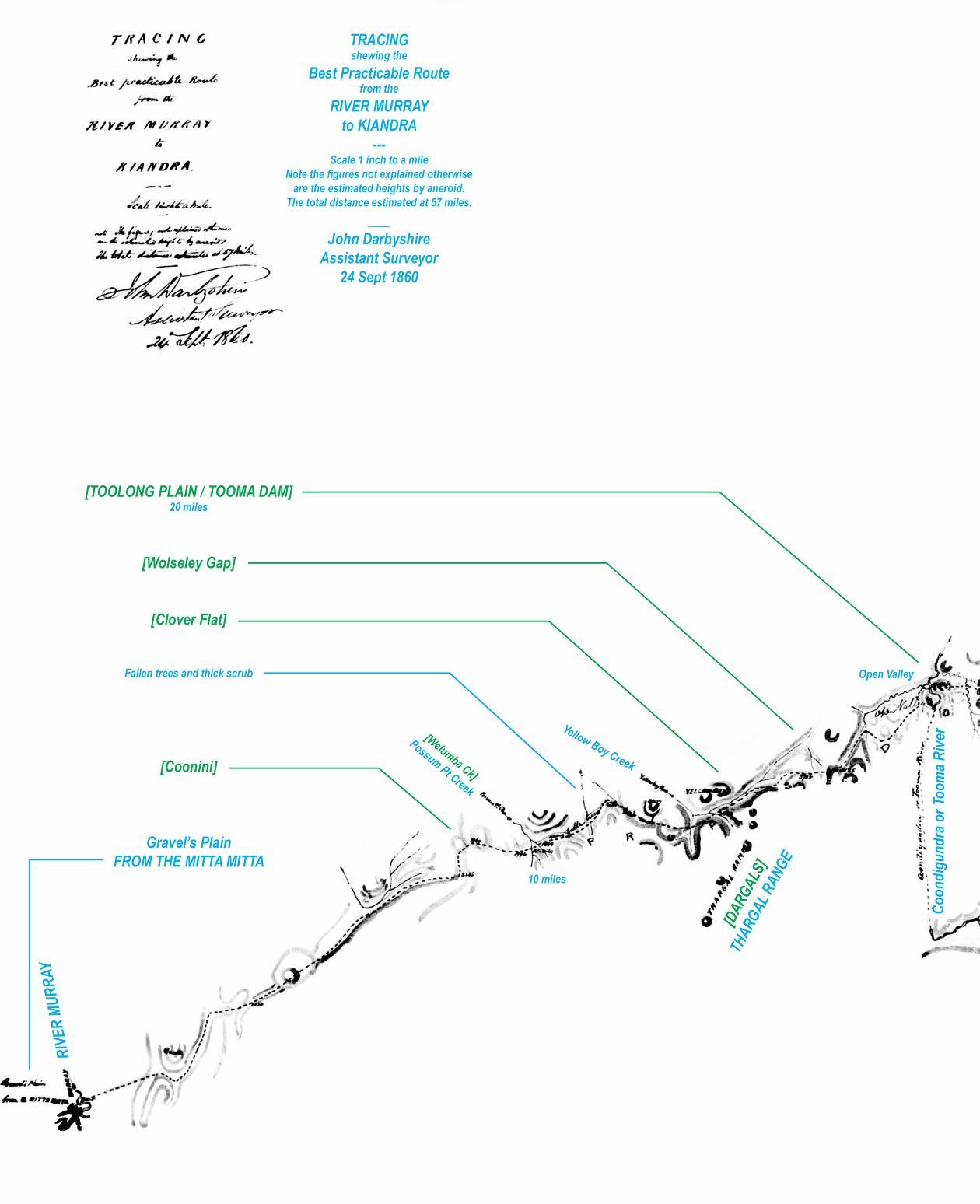
Image 1: Ligar's Route from the River Murray to Toolong Plain
Surveyors General & Interstate Intents
The forecast population of Kiandra for the Spring was an issue of importance to Victoria and South Australia as it included tens of thousands of their own colonists. If appropriate arrangements could be made, then a goodly proportion of the revenue generated by Victorian and South Australian miners would make it back to their home colonies. On top of which there was potential commercial opportunities in supplying Kiandra from these colonies by road or by steamers along the Murray River.
Both colonies placed their Surveyors-General on notice to set aside their crucial business of surveying each colony for settlement and transport communications, and travel without delay to Kiandra. The Surveyors-General of Victoria and South Australia were the most senior government officials to visit Kiandra during the rush, indicative of the national interest if not importance Kiandra had assumed.
Their purpose was to assess the likely potential of the goldfield and confirm the most appropriate routes by which their colonists could travel to and from the goldfield. Each followed a different approach towards these ends.
Major Freeling pursued an open and transparent course, notifying and soliciting support from the NSW Government. His journey and findings being widely publishing across South-eastern Australia.
By the time of his departure from Adelaide on the 3 April 1860, ships had been running special services out of Adelaide to Kiandra for three weeks, dropping people at Melbourne to proceed overland via coach. Freeling travelled via Beechworth and Adelong, arriving at Kiandra on 19 April. He was accommodated as the guest of Chief Gold Commissioner Peter Cloete, who had been directed by the Secretary of Lands to “have the goodness to afford Major Freeling such facilities and information as may be in your power for carrying out the mission with which he has been entrusted.”
Shortly after a heavy fall of snow on 23-24 April, which threatened to close off access to the goldfield, Freeling departed Kiandra on horseback for Eden. The swollen Eucumbene could barely be crossed with water up to the saddle flaps. At Eden Freeling paused briefly to draft his report findings before embarking on the City of Sydney on 2 May, returning to Melbourne and thence Adelaide.
Freeling’s recommended route for South Australians was by ship to Eden thence overland via Cooma and Adaminaby. This route was also utilized by Sydneysiders as it offered the shortest walk or horse-ride to Kiandra. Freeling’s report has special importance in providing one of the most detailed descriptions of the Kiandra Goldfield at the height of the rush.
During the last week in May, the Victorian Surveyor-General Charles Whybrow Ligar departed Melbourne for Kiandra. The Melbourne press provided a glimpse of his true mission — to ascertain whether it was worth the Victorian Government fighting for a share of the revenue from mining and supply of the goldfield, and to ascertain a ‘best route’ for Victorians — that avoided the proposed NSW Customs Houses! The press reported:
“We are glad to observe that the Government . . are not unmindful of the importance of the Kiandra trade to this colony . . Mr Ligar, the Surveyor-General. . intends to proceed towards Kiandra, with Mr [Alexander] Martin, the district surveyor, and Mr [Francis] Ryley, the road engineer.
“Now that the New South Wales Government . . have declared war by the re-establishment of Customs officers on the borders, it is time for Victoria to prepare actively for what is before her.”
Ligar and his party departed Beechworth on horseback around the 6 June, arrived at Kiandra on the 13th, where they stayed one or two nights, seemingly without meeting any officials, and was back in Beechworth telegraphing his report on the 21st. A fifteen-day return trip on horseback from Beechworth to Kiandra can only be summarized as a survey being conducted off the back of a cantering, if not galloping, horse!
Ligar never actually followed his proposed route. The Age correspondent reported Ligar had surveyed a route from Beechworth to the Murray near Tintaldra, where he was unable to proceed due to the swamps and high steam flows, so he diverted north through Meragle to Lobbs Hole. Having entered town from Lobbs Hole, one press report even stated he had found “a good passable, road from Lobb's Hole to Kiandra”! From discussions with squatters enroute, Ligar learned of bridle paths from the upper Murray up to Toolong Plain and across to Kiandra. Confident of the likely existence of a trafficable route, Ligar was able to declare he had found such a route prior to NSW reopening its Customs Houses.
If ever in doubt, the politics of Surveyor-general Ligar’s mission become obvious at the time of his announcement. To put pressure on the NSW Government to abandon its Custom House re-establishment, Ligar had to urgently declare there was one or more routes by which Victorians and Victorian supplies could pour into Kiandra bypassing any Custom Houses. Whether the route was indeed practicable was of less importance than the timing of the announcement. Indeed the practicality was highly questionable.
Immediately upon his return to Beechworth, Ligar despatched Assistant Surveyor John Darbyshire back to survey and mark with blazed trees the untraced section of his route from the Murray to Kiandra.
Darbyshire’s Impossible Task
The early winter had been mild, it is possible Ligar encountered minimal snow cover on his visit to Kiandra and believed the rumours of deep snow were just a myth. However, it was sheer folly to send Darbyshire on a mission over several of the highest mountains in Australia in the midst of winter!
Not only was Darbyshire directed to survey and blaze a route, he was instructed to take a dray to prove the viability of the route as a means of delivering supplies to Kiandra! This request confirms that Ligar either wholly lacked an appreciation of the conditions or was ambivalent about the true purpose or success of Darbyshire’s mission.
Darbyshire proceeded mostly along the route Ligar had taken from Beechworth via Tallangatta and Cudgewa Creek to reach the Murray River near present day Towong, where he established a base at Mathew Hervey’s station on Gravel’s Plains.
Rather than proceed up the Tooma River to Possum Point station, where a bridle path had been established by pastoralists along First Nation footpads up Welumba Creek and over Wolseley (Port Phillip) Gap onto Toolong Plain (Tooma Dam), Darbyshire took a direct line up the range following another track that converged with the other near Welumba Creek. To get his dray in to Toolong Plain, Darbyshire would have had to clear substantial sections of track including an especially steep and scrubby section above Welumba Creek known as ‘The Devil’s Elbow’. Most probably he had abandoned the dray by this point. At Toolong he found a gold diggings being worked.
The next section over Toolong Mountain and around Mt Jagungal to emerge onto Happy Jacks Plain at Doubtful Gap crossed undulating scrubby and snow-covered terrain at higher altitude. Any bridle track or ancient footpad would have been little visible and Darbyshire would have minimised his time at this altitude, blazing a line of trees without clearing a path. From Happy Jacks to Kiandra the course would have been relatively simple but for the snow, along rough tracks developed by miners to work the plain and Upper Tumut valley.
The detail on Darbyshire’s original survey plan (attached with annotations by D Scott) indicates he succeeded in his traverse of the mountains to Kiandra, returning to Beechworth and completing his survey plan by the end of September 1860. His achievement in plotting a course through a remote snow-covered wilderness at the height of winter was a remarkable achievement, however impracticable his mission.
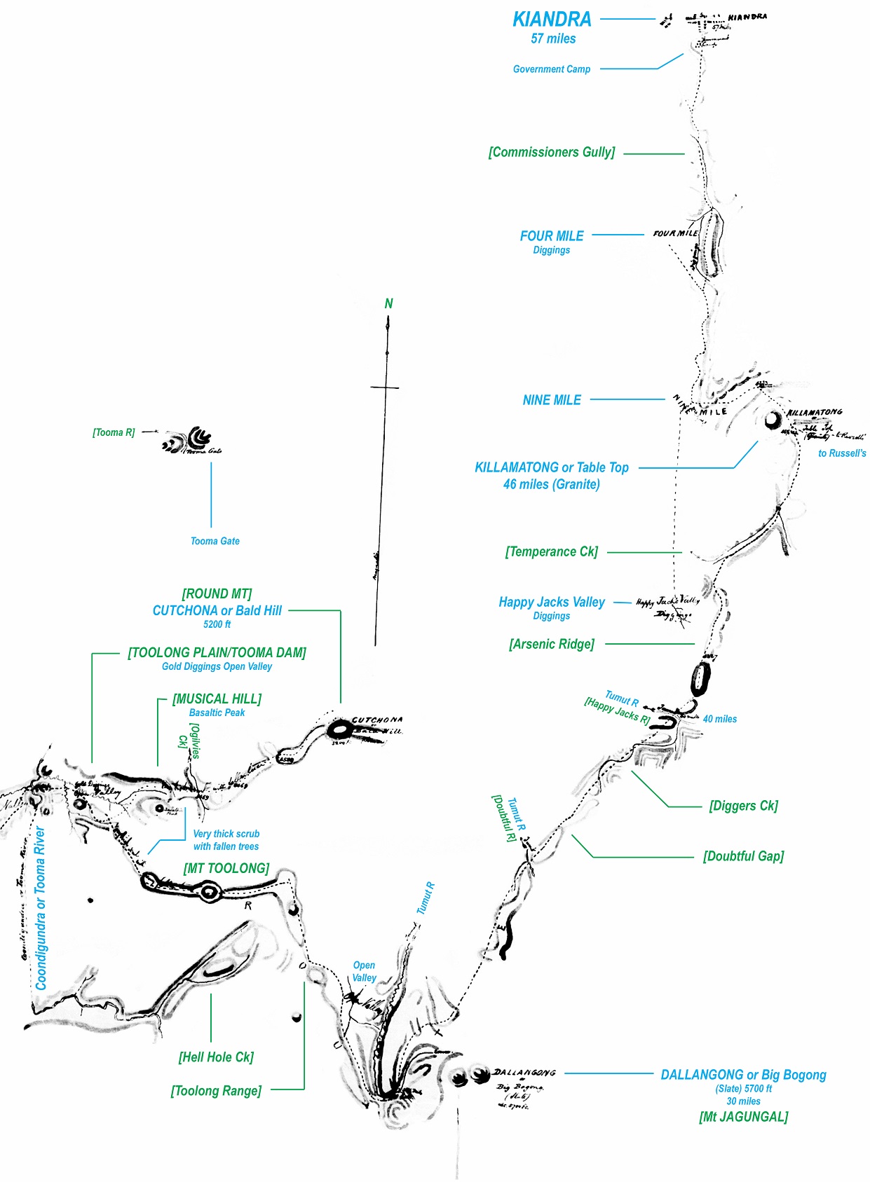
Image 2: Ligar's Route from the Toolong Plain to Kiandra
Success and Failure of Ligar’s Route
The promotion of Ligar’s Route was successful in serving its political purpose of providing leverage against the re-establishment of the border Custom Houses by NSW. By the end of the Kiandra Goldrush in mid-1861, import duties were still not being collected on Victorian goods crossing the Murray.
However, Ligar’s ‘Best Practicable Route to Kiandra’ was wholly impractical as a travel route and was never well-patronised. From the outset, it was criticised for understated distances, difficulties with the terrain, scrub, and the crossing of the Murray River and inexorable creeks, as per press reports:
“Five bullock drays . . returned to Albury after becoming hopelessly bogged on Ligar’s supposed road . . .
“One or two parties . . compelled to return . . report that the line of country is almost impassable, and . . doubt the existence of any such route as that indicated by the Surveyor-General.
“Several parties . . induced by the report of the Victorian Government surveyor to take the route through the Kiandra mountains to the Snowy River, and . . I am afraid have fallen victims by perishing in the attempt . . .
The other day, a Mr Bloxome, who tried it, after wandering he knew not where reached The Ponds [Pound] Station, on the Tooma River, with scarcely a stitch of clothes on his back, he and party having been out five days without food or fire. Some have not yet been heard of, and it is feared have perished”.
The above statements are typical of those who attempted Ligar’s Route. Once off the path, some of the adjoining areas are exceptionally rugged – particularly around the Tooma River where one locale is known as ‘Worlds End’.
Whilst no deaths were reported along Ligar’s Route, it is entirely plausible that people enroute for Kiandra perished in attempting the Route and their bodies have never been found.
As for the Victorian Surveyor-General? He soon shifted his energies to another folly — Chairing the Exploration Committee through the final planning of the ill-fated Burke and Wills Expedition.
Ligar’s Route Today
Other than its diversion around Lake Hume, the Victorian segment of Ligar’s Route is believed to follow roads that have been developed along the line of the early tracks between Beechworth and the Upper Murray.
The NSW section, particularly that within Kosciuszko National Park retains a higher degree of public interest. The author has been working with the Kosciuszko Huts Association and NPWS in investigating how historical routes such as Ligar’s should be acknowledged within the context of the current National Park.
The section west of Tooma Reservoir is particularly steep and wooded. The section over Mt Toolong wooded but less rugged. The remainder is reasonably open and suitable suitable for promotion as an historical walking route; not necessarily for construction as a trail but consideration of signposting – be it physical or electronic/virtual on a portable device.
These are the sorts of questions currently being explored.
****************************************
Author:
David Scott
Post-graduate student, Lincoln University, NZ
David is a heritage architect who works with the ACT Government, ACT Environment. He was responsible for the preparation of the Namadgi Plan of Management review.