

by Graham Scully; KHA Heritage Officer
Access
There are essentially two ways into the Collins Creek Gold Diggings; either from the National Park campsite on the Gungarlin River near Diggers Creek or from the Snowy Plains Fire Trail as described in the entry for Kidmans Hut.
Both routes meet at the junction of Collins Creek and Teddys Creek. From there follow the route into Kidmans for about 2 km. The track is shown on the Nimmo Plains topographical map. Shortly after Mill Flat one diverts off the Kidmans track.
At about position 35120/91760, there is an open area/clearing to the east of the track which is followed through some boggy parts to a small creek which heads down in a SE direction to Collins Creek for a little over a kilometre. Signs of a benched track were visible in 2003.
It was known that miners had worked the area, that there was a hut, a grave, a “dog’s” grave and some diggings. The miner who was buried there was responsible to mind the water supply so as to ensure that each day water was sent down the creek to mine workings further downstream. One day the water did not reach the diggings and on inspection the miner was found to have died. He was buried on the spot.
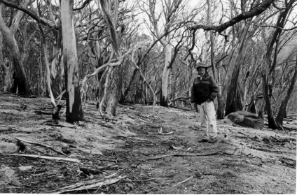
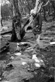
The photograph shows the miner’s grave and was kindly supplied by Graham Scully. Graham (shown in the photograph) was first taken to the Collins Creek diggings by Fred Fletcher in 1992 in a heavy thunderstorm. They could only make a cursory search, finding a small cairn, a grave but not the miner’s hut site.
After the 2003 fires Graham revisited the area. The fires cleared the groundcover and the quartz stones outlining the grave were plain to see.
Greg Hutchison and Robert Green returned to the area in 2009 to see what could be found.
They recorded:
- Miner's hut on Collins Creek 35404/90980 remnant log cabin with pile of chimney stones
- Miner's well near hut 35420/90985
- "Dogs grave" 35362/90968 Look for 3 quartz stones beside a tree
- Miner's grave 35321/90956 Look for a rectangular arrangement of quartz stones beside a tree stump about 2m high in 2009).
The old track from Daveys Hut to Constances Hut
As mentioned previously, the Bolton’s and others used a stock route part of which went from near Daveys Hut across to the Burrungubuggee River. Others who used the stock route, at least as far as the Burrungubuggee River, included the Constance’s, Reid’s and Hedger’s. But it was not solely a stock route. Around 1900, Napthali’s homestead was the social centre for the district and this route linked the families living near the Burrungubuggee River to the rest of the district on Snowy Plains.
Later the SMA bulldozed the track to improve the access from the Nimmo area to the Burrrungubuggee River. This track appeared on SMA maps as recently as 1967.
Phillip Crampton long had a desire to locate it. Two attempts to find it with Graham Scully and Vaughan Evans failed. However, the fires of January 2003 and the removal of deep forest litter enabled Vaughan and Phillip to find some of the track in the autumn of 2003.
Returning in the spring of 2003, Graham Scully and Phillip were able to GPS the complete route from Daveys hut to the Constances hut site. (In 2003 the rocks, lining sections of the track were quite clear, but by 2009 this was no longer the case.)
Ross Bolton also helped with a description of the route.
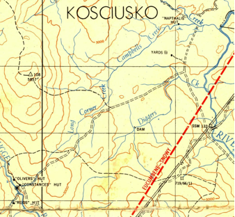
| The photograph shows Phillip Crampton beside the track when it was rediscovered after the 2003 fires | An extract from the SMA 1962 Nimmo map. | Graham Scully at the Miners grave |
 |
 |
 |
The route
In 2003 Phillip recorded GPS positions for the route. These were later used as a guide to follow the track and record Waypoints using the WGS84 datum.
Since 2003 there has been considerable regrowth and at times the track itself can only be identified with difficulty. In some areas bush has reclaimed it, but for the most part the walk is through open forested country.
As Phillip noted, its location is very logical. It still represents a viable route to get across to the Burrungubuggee area from Snowy Plains. It may, in fact, be faster to go this way, from Daveys Hut to the site of Constances Hut, than to use the Island Bend Fire Trail and the track along the Burrungubuggee River. All of the GPS references in this document are on the WGS 84 datum.
The following notes are essentially those made by Phillip, with the exception that the Waypoints are those identified by Greg Hutchison and Robert Green in 2009. There has also been some updating of track conditions. The waypoints are not equally spaced and it would pay to plot them on a topographic map before using the route.
“The starting point is Daveys Hut, 37852/89447. Track remnants will be seen from time to time. From Daveys Hut follow the track in a SW direction to a low saddle (37618/89140) and then head immediately to the remains of an old gate and fence. Continue to the south west and when you reach a small creek veer to the right up the creek before crossing it.
Continue on the track until you reach a swampy area. Ignore any wheel marks which turn off to the east as these lead to John Bolton's homestead. Keep to the eastern side of the swamp and turn uphill. (37247/88687).
The track climbs the low hill ahead, veering to the right and comes out on a grassed plain. (37049/88585).
Proceed along the western side of the plain and enter the tree line at the junction of the track and an old gold mining aqueduct. (36436/88252).
Walk into the trees and sidle around the western side of the slope. Points on the old track can be seen about 36281/88201. Proceed to the ridge/saddle at 36108/88091 and continue straight down the hill, crossing a small creek, continue up the other side, and across a small plain, entering the tree line at 35839/87952.
Go through a low saddle leading to another clearing containing the junction of two small creeks. Cross the LH creek near this junction. (There is good water here at 35574/87737.) Continue up to another plain. Head uphill across this plain entering the tree line (and obvious mountain slope) at 35495/87480.
Head up the spur which flattens a little at 35293/87022. From here on the track has largely disappeared and is covered by regrowth. (Suggestion: Keep to the west of the regrowth. Glimpses of the track can be seen up around the ridge line.)
Continue up the spur veering right, crossing the range at 35112/86750.
Proceed directly ahead down the slope. The track made a sharp turn to the left at 34947/86638.
The track now runs gently downhill to nearby Green Flat, which is obvious when you get there, 34844/86544, and continues in the same line to the spur in front.
Continue to the top of this spur at 34694/86334.
Proceed down the spur towards the ruins of Burrungubuggee Hut and Constances Hut.”
(Graham Scully and Phillip Crampton)
[In November 2009, the track down the hill towards the sites of Burrungubuggee Shelter and Constances Hut could no longer be followed. The track did not aim directly for the hut sites but instead crossed to the western side of the spur and then, for the last several hundred metres before the hut sites, approached that position from the gully to their northeast. Points on the spur are at 34613/86261 and 34533/86253.]
Further walking
From the Burrungubuggee Hut area there are several possibilities.
One could carry on across the river following the historic route and then go on to Tin Hut.
One could return to the Diggers Creek area along the Island Bend Fire Trail as a day walk.
Or one could go up along the Burrungubuggee towards Kidmans. (There is a fishermen’s track along the eastern bank of the river for some distance upstream from the site of Constances.) It is about 2½ hours from Constances to Kidmans but this time will increase with the more regrowth. The walk itself is along the river and it is a pleasant route with some regrowth.
Graham Scully KHA Heritage
Waypoints for track from Davies Hut to Constances Hut
| 1 | 37741-89260 |
| 2 | 37487-88920 |
| 3 | 37275-88715 |
| 4 | 37174-88578 |
| 5 | 37112-88442 |
| 6 | 37004-88428 |
| 7 | 36948-88416 |
| 8 | 37317-88825 |
| 9 | 37083-88801 |
| 10 | 36974-88732 |
| 11 | 36996-88592 |
| 12 | 36924-88385 |
| 13 | 36807-88324 |
| 14 | 36592-88235 |
| 15 | 36468-88179 |