

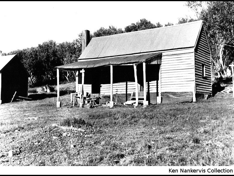
Boobee Hut is a 2009 rebuild of a Salt & Harness Shed built for John Cheney jnr c1930. The original residence at the Boobee was a two-room weatherboard cottage just north of the hut which was built by either Cheney around 1920, or by Bill Byatt in the 1890s when he was mining for gold on Diggers Creek.
Happy Jacks Plain was first grazed and mined for gold in the mid-19th century. In 1860-61 gold miners who had come to the Kiandra Rush are believed to have tried their luck on Diggers Creek below the hut. During the late 1880s-90s Bill Byatt and party constructed extensive racelines and dams to hydraulically sluice the sides of the creek, and Tom Taylor also worked the diggings 1932-35.
Diggers Creek valley was part of the New Maragle Block B squatting run in the late 19th century. By the early 1900s, the area had been divided into small leases, one of which was acquired by John Cheney jnr in 1917. He later claimed to have put in five bids for leases and only been successful in his least preferred choice — the ‘booby prize’.
From that time on, this area and its huts were known as ‘the Boobee’. Cheney ran stock on the lease for the summer months up to the 1940s, following which Reid and Brooks, followed by McPhie and Fletcher, held leases over the area until 1958 when all grazing above 1370m was terminated.
The cottage burned down in 1964, and in the 1970s the Salt & Harness Shed was adapted into a shelter hut by the Canberra Bushwalking Club.
[Level 1 text = 58 words)] [Level 2 text = 209 word addition to Level 1]
Boobee Hut – Historical Background – DScott 2018
Pastoralists are believed to have been grazing stock on Happy Jacks Plain by the 1850s, and may have been there as early as 1834 when Dr Gibson, George Palmer and William Pitt Faithfull lost cattle around Kiandra. By the Kiandra Gold Rush of 1860 there were bridle paths into and across the plain. A route from Bringenbrong to Kiandra through Happy Jacks was traced by the Victorian Survey Office to assist Victorian miners travelling to and from Kiandra — known as Ligar’s Route. In 1860-61 miners spread out through the upper catchment of the Tumut River. It appears some worked the creek below Boobee Hut as it took the name ‘Diggers Creek’.
By the mid-1880s Happy Jacks Plain incorporated a 25,000 acre squatting run with the unromantic title New Maragle Block B. The western end of the plain was subsequently divided into smaller leases taken up by Archibald Joseph Rial from 1895 to 1917. Rial established a homestead at Farm Ridge and had numerous leases extending from the Tumut River in the north to Whites River in the south.
Around the late 1880s-90s, a group of miners including Bill Byatt set up a hydraulic sluicing operation on Diggers Creek. Water was brought from Tibeaudo Creek to a large earth wall dam thence via a series of racelines to Diggers Creek. At least three small sluiced areas are still visible on the south side of the creek below the races; the main dam is evident 800m north of Mackeys Hut whilst the small feeder race passes ~30m behind Mackeys Hut as it crosses the watershed out of Tibeaudo Creek. Byatt had finished mining prior to 1902 when he purchased the Alpine Hotel in Kiandra; selling up and moving to Tumbarumba in 1904.
In 1917, John Cheney jnr (‘Jack’) from Humula acquired a snow lease of 9,330 acres over the area. The Cheney family were early settlers in the Humula district and were prominent in the development of the Humula township. Apparently in the 1917 ballot for leases, Cheney placed bids for five and was offered his least-preferred option. He claimed to have won the ‘booby prize’. This part of the plain became widely known as ‘The Boobee’ and the hut took that name.
By the early 1920s there was a 2-roomed weatherboard cottage with a verandah at the general location of the present hut; labelled ‘Boobee (Cheyneys) Miners Hut’ on a 1925 Dept Lands’ map. It either had been erected in Byatt’s time or was relocated to this site around 1918-19 by Cheney. Fred Fletcher suggested it had been the mine manager’s hut at the Nine Mile, relocated by Tom Yan when the mine sold up c1925, but more likely it came from closer by. This cottage was situated 10m to the northeast of the current hut. A two-roomed corrugated iron salt and harness shed was located on the site of the present hut, probably by this time, certainly by 1933. A stable (construction unknown) was situated just to the south.
Cheney held the Boobee lease through the 1930s, possibly into the 1940s. Boobee Hut was described in the 1933 and 1934 Australian Ski Yearbooks: “These two huts, situated on the SE slope of the Far Bald Mountain . . would be extremely useful to a party negotiating the country between Kiandra and Kosciusko. . . They stand on the edge of timbered country and are easily visible from the east from a distance or some miles during clear weather. . . Equipment: bunks and cooking utensils . . no provisions . . no guarantee of their condition can be given . . according to the latest information, they are not habitable as all the windows are missing.”
From 1932-35 Tom Taylor held two mining leases over parts of Diggers Creek, and appears to have stayed at the hut whilst working the area; subsequently trying his luck with Bill Harris at Yorkies Diggings on Long Plain.
In 1943 the land proposed for inclusion in the Kosciusko State Park was divided into small snow leases of around 2,000 – 3,000 acres. From 1943-50 the Reid & Brooks families held snowlease Block Y8 of 2600 acres which included the Boobee Hut. The stable was dismantled or relocated for use in a hut elsewhere by Brooks at this time.
From 1950-57 the McPhie family (including William) and Fred Fletcher were the last graziers on the Boobee. Fletcher described the salt and harness shed as being red painted corrugated iron at that time, for which he paid the previous owners about $100.
In 1958 all grazing above 4500’ (1370m) was terminated. McPhie and Fletcher left the buildings at the site. They came to be used by passing bushwalkers but in 1964 the weatherboard cottage was destroyed by an escaping internal fire.
In the early 1970s, the Canberra Bushwalking Club took an interest in the derelict salt and harness shed as a recreational shelter and undertook a major rebuild. They repaired the roof, removed the internal partition to make it one room, re-laid the floor, installed an elevated sleeping platform, and replaced one of the old doors with a 2m high window. They also installed a slow combustion stove, taking three days to move the component parts in to the site by barrow. A sign-plate Boobee Hut was installed above the door and a rather un-PC picture of a voluptuous woman in ‘70s clothing was hung from a wall inside.
In 1978 someone drove cross-country in a 4WD to Boobee Hut and stole the stove. In 1980 volunteers built a new bush fireplace using corrugated iron, bush poles and fencing wire which worked better than most KNP hut chimneys and looked like it had been there for decades.
Boobee Hut burnt down in the 2003 bushfires. It was rebuilt in 2009 through the efforts of Kosciuszko National Parks staff and KHA volunteers. A few minor changes were made — a Beaconlight kitchen stove, possibly salvaged from the site of the weatherboard cottage, was installed in the middle of the floor; a small window was added in the northeast wall and a rather grand set of stone steps was built to sit on at the doorway.
Documentary Sources
Freeman & Randell, Boden, Rogers & Jefferies: Boobee Hut Heritage Action Statement, NPWS 2002.
Gilder, Colin: Skiing Huts of NSW, ASYB 1933; 53 Ski Huts of NSW, ASYB 1934.
Hueneke, K: Boobee Hut - KHA Information Sheet #6, c1977; Huts of the High Country, ANU Press 1982; People of the Australian High Country, Tabletop Press 1994.
KHA records, database and images.
NSW Dept of Land and Property Information: parish maps c1880s-1970 (Clear Hill), snow lease plans 1943-68, mining lease plans c1870s-1930s.
Some Nearby Points of Interest
The outline and fireplace stones of the original cottage 10m to northwest
The view from the summit of Far Bald Mountain. Navigable route up ridge from location 100m northeast of hut, then follow fire trail east. 2.5km/~45 mins each way.
Diggers Ck mine workings 1km south of hut. Racelines & hydraulic sluice cuts in opposite/southern bank; excavated pit(s) in creek flats. Large dam with 70m long wall 800m north of Mackeys Hut, plus feeder races to south from Tibeaudo Ck and western tributaries of Diggers Ck.
Amenity
Water – in small creek 100m to south west. Low flow may be problematic in hot/dry conditions.
Toileting – no outhouse. Please go along treeline northeast of hut or spur southeast into plain, keeping well away from the water supply gully to the west.
Firewood – plentiful along treeline to northeast and southwest
Nearest Phone Reception Point in an Emergency – outside front of hut (??)
Nearest Trackhead/Public Road – Happy Jacks Road junction with the Cabramurra-Khancoban Rd ~20km (5.5 hr walk), infrequent traffic and road closed in winter.